L. V. Averyanov, Phan Ke Loc, Nguyen Tien Hiep, D. K. Harder The northeastern and southwesterm frontiers of Vietnam are formed by the waters of the Bac Bo (Tonkin) and Thailand (Siam) Gulfs of the South China Sea. The coastline of mainland Vietnam extends nearly 3440 km. A large number of islands, mainly of continental origin and also numerous small coral atolls are included in the territory of Vietnam. The Annamite mountain chains, mainly the Den Dinh, Sam Sao, Hua Phan and Truong Son Ridges form the natuaral western Vietnamese boundary with Laos and Cambodia.
Tin mới nhất
- Hội đồng nghiệm thu sản phẩm và đánh giá, nghiệm thu tổng kết đề tài KHCN cấp Tỉnh: Nghiên cứu chọn giống, nhân giống và trồng Mắc ca (Macadamia) theo hướng thâm canh cho năng suất quả cao tại tỉnh Lạng Sơn
- Hội đồng đánh giá, nghiệm thu kết quả thực hiện nhiệm vụ khoa học và công nghệ quỹ gen cấp quốc gia: "Nghiên cứu khai thác và phát triển nguồn gen cây Gụ lau (Sindora tonkinensis A. Chev. ex K. & S. S. Larsen) tại một số tỉnh duyên hải miền Trung.
- Hội đồng nghiệm thu tổng kết nhiệm vụ quỹ gen cấp Quốc gia: Nghiên cứu bảo tồn và phát triển cây Hoàng đàn Hữu liên (Cupressus tonkinensis Silba.J.) ở một số tỉnh miền núi phía Bắc Việt Nam”.
- Hội đồng nghiệm thu tổng kết đề tài KHCN cấp Tỉnh: “Xây dựng mô hình nhân giống, trồng thâm canh cây Giổi lấy hạt và xây dựng nhãn hiệu sản phẩm “Hạt Giổi” tại tỉnh Lai Châu”
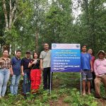
- Hội thảo đầu bờ về nhân giống trồng thâm canh cây Giổi ăn hạt tại Lai Châu
Các tin khác
- Conservation prospects for threatened Vietnam tree species: results from a demographic study
- Kết quả phân tích đa dạng di truyền loài sao lá hình tim (Hopea cordata Vidal) thuộc họ Dầu (Dipterocarpaceae) bằng chỉ thị phân tử
- Nghiên cứu cơ sở khoa học để xác định đường kính khai thác tối thiểu hợp lý đối với cây rừng tự nhiên ở khu vực Tây Nguyên
- Conservation Status and Breeding Work of Conifer Species in Vietnam with Reference to Pines
- Giá trị môi trường và dịch vụ môi trường rừng